LINKS CONTACT US

Transportation

UIP is centrally located to many California major markets and provides excellent logistic options for businesses. UIP is conveniently located between Highway 99 and Highway 140, providing direct access to the western major markets by truck or rail.

Highway 99: The newly constructed Mission Interchange provides direct access to UIP from Highway 99 and is designed to accommodate heavy truck activity. Highway 99 is one of the two major north/south trucking arteries that serve California. Highway 99 has increased from four to six lanes in several sections within Merced County and is planned to eventually be six lanes.

Highway 140: The northern boundary of UIP is Highway 140, which is the west/east artery that provides a direct route to Interstate 5.

Interstate 5: Is the main Interstate Highway on the west coast of the United States, running north/south from Mexico to Canada (California to Washington). It serves some of the largest cities on the U.S. West Coast, including Seattle, Portland, Sacramento, Los Angeles, and San Diego, and also links the capital cities of Washington (Olympia), Oregon (Salem), and California (Sacramento) together. The highway's southern terminus is the Mexico – United States border and its northern terminus is the Canada – United States border; it is the only Interstate highway to touch the U.S. borders with both Canada and Mexico.

Highway 132: State Route 132 is a west/east route in the Central Valley that leads to the Sierra Nevada foothills and the California Gold Country. It also connects the city of Modesto with the San Francisco Bay Area via I-580. Route 132 is a two lane road important to recreational travelers en route to Modesto Reservoir, Turlock Reservoir, Don Pedro Reservoir and the Sierra Nevada foothills.

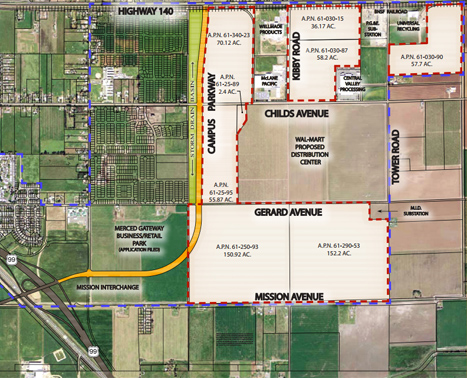
Campus Parkway: This parkway will connect Highway 99 to rapidly growing areas in the City of Merced. It will be one leg of a loop system to improve commuter and goods movement traffic flow and provide a primary link to the University of California and the planned University Community. The Campus Parkway is a 4 lane expressway on the east side of the City of Merced, from Highway 99 to Yosemite Avenue – about 4.5 miles. The project is part of a loop system that will better connect communities and relieve congestion.

Rail: The Burlington Northern Santa Fe (BNSF) railroad serves UIP with rail spurs located on several sites. A mainline track and switching yard are located adjacent along Highway 140. Merced is within a local dray zone of two major intermodal ramps featuring double-stack service. Container facilities and/or bulk shipping facilities within 100 miles of Merced include the ports of San Francisco, Oakland, and Stockton. The port of Los Angeles-Long Beach is within a 275-mile radius.


View Larger Map

Ports: Three different inland ports are located within 100 miles of UIP including San Francisco, Oakland and Stockton.

Airports: Two airports serve the Merced region. The Merced Regional Airport and Castle Airport. Merced Regional Airport currently offers corporate facilities. Fresno Air Terminal, about an hour to the south, offers more than 90 daily commercial flights via Alaska Airlines, Allegrant Airlines, America West, American, Continental Airlines, Delta Airlines, Frontier Airlines, Hawaiian Airlines, Horizon Air, Northwest Airlines and United. Five international airports (Oakland, Sacramento, San Francisco, Fresno and San Jose) are within a two hour drive.

Castle Airport is a public airport located seven miles northeast of the central business district of Merced, Merced County and serves a regional population of over 310,000 people. The airport is located just outside the city limits of Atwater and three miles northeast of downtown. The 1,580 acre single runway facility is operated by Merced County. Castle Airport has the sixth longest runway in California (11,800 feet long, 150 feet wide) and is open 24/ 7 for general aviation operations.


Infrastructure

UIP has available water, sewer, gas and electric services. Water service is provided by the City of Merced with extension necessary from Childs Avenue. Sewer service is also provided by the City of Merced. A water main and sewer main are located in Childs Avenue. Gas is provided by Pacific Gas & Electric (PG&E). There are two energy companies that service UIP, PG&E and Merced Irrigation District (MID) which both offer competitive rates. Both have outstanding service records and offer incentives for energy efficiency.

UIP is zoned Heavy Industrial.

Wastewater Discharge Capacity: Plans are underway to expand the capacity of the Wastewater Treatment Plan from 10 Million Gallons Per Day (MGD) to 20 MGD. Phases 4 and 5 were completed by the City expanding the current capacity to 12 MGD.

Water: The City’s water system has more than adequate capacity to serve industrial users. Water wells are strategically located near and within UIP. All wells are looped to provide sufficient flow and pressure.


UIP Site Plan
Click the image for larger view

Merced University Industrial Park      •      1212 K Street      •      Modesto, CA 95354      •      (209) 575-5900      •      mark@merceduip.com

Information contained herein has been obtained from sources we deem to be reliable. We have no reason to doubt its accuracy but in no way do we guarantee it.
No warranty or representation express or implied is made as its accuracy. It is your responsibility to independently confirm its accuracy and completeness.

© 2014 Merced University Industrial Park. All Rights Reserved. Powered by  Imedia West